
The state of Minnesota may have over 10,000 lakes, but Blue Earth County has rivers; eight rivers and numerous creeks, like Minneopa or Willow. Traveling in or out of Mankato in early years meant fords, ferries, or swimming, as there were no bridges in Blue Earth County.
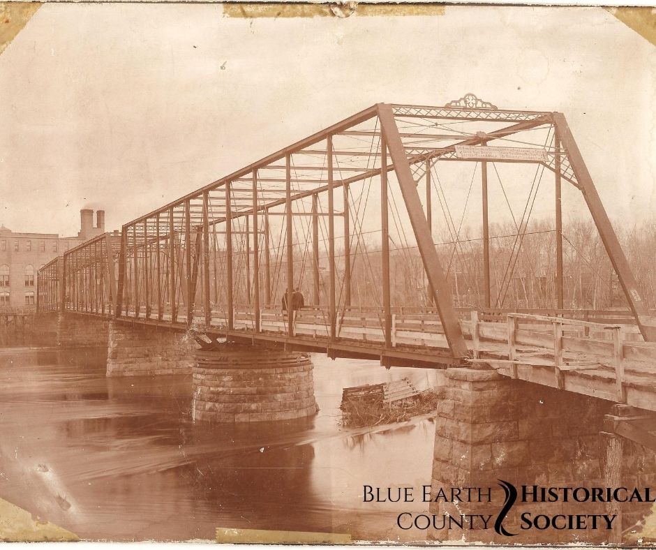
The first bridge in Southern Minnesota was the Military Bridge over the Blue Earth River, linking Mankato and LeHillier, built in 1856. It was a small piece of a road that was to run from the Mississippi River at Fort Snelling to the Missouri River at Sioux City, Iowa. The surveyed road was sometimes referred to as the Old Territorial Road or Reno Road, named for Captain J.L. Reno who led the survey crew and usually referred to as the Dodd Road beyond Mankato and St. Pater. Beginning in Sioux City in 1855, the survey crew entered Blue Earth County along Perch Creek in Cresco Township. Proceeding along the south side of the Watonwan until it met the Blue Earth (then called the Mankato River), but finding it not a good route, the survey crew returned to near Perch Creek and crossed the Watonwan. The route continued between present-day Loon and Mills Lakes, to the mouth of the Blue Earth River. Reno noted in his survey report, “after passing over 180 miles of Prairie, unoccupied by a single white settler, we were agreeably surprised to find at the mouth of the Mankato a flourishing settlement of 200 intelligent and energetic countrymen.”
After crossing the river, the survey team continued through the little town of Mankato along Front Street, then moved further east on approximately 2nd Street. The surveyed route followed the east side of the Minnesota River until opposite Traverse de Sioux where it met the Dodd Road, recently surveyed and cut by William B. Dodd and his crew. This was a privately financed road, unusual at a time when roads were laid out and financed by the government to help bring settlers into the area. The Dodd Road continued to Fort Snelling.
The Military Bridge across the Blue Earth was built at government expense for a cost of $10,000. It was partially enclosed, with a roof and slated sides, and served until 1931 when it was replaced with a concrete bridge. There was limited construction along the surveyed route west of Mankato even after the bridge was built. Only about seven miles of the road were completed, out of the valley and up Pigeon Hill.
The County Board passed a resolution in 1873 to build twelve bridges in the county, at an estimated cost of $70,000. It required authorizing a levy of one mill. Among the bridges proposed were crossing the Blue Earth at Jones’ Ford, Rapidan, Shelby, and Vernon Center, crossing the Watonwan at Garden City and Cresco, crossing the Maple near Good Thunder, the Cobb near Beauford, the LeSeuer at McPherson and Decoria, Little Cottonwood at Cambria, and a bridge across Morgan Creek.
Crossing the Minnesota River was even more difficult. Ferries were used as early as 1854. The Cummings Ferry crossed the River, from the north part of present-day Sibley Park to near Belgrade Hill during the 1870s and ’80s. This ferry was winched by horses, using a heavy cable across the river. It began as a private ferry and later was operated by the city. It carried wagons, teams and passengers at a cost of 10 cents a team. The ferry’s principal passengers were farmers from Nicollet County, bringing their produce to market. During the early years, other ferries operated for brief times across the Minnesota north of the present Main Street Bridge, near Judson from a small community north of the river called Eureka, and across the Blue Earth to South Bend.
The first bridge across the Minnesota River was built in 1880, near the present site of the Main Street Bridge. The engineers would not have selected that site for a bridge, but the vote on the bond to raise the money designated that location, and would not have applied to another site. The structure was to cost $28,500, paid in part by the city of Mankato, Nicollet County, and Belgrade Township. The contractor was Wrought Iron Bridge Company of Canton, Ohio. The bridge was 810 feet long, and contained three spans, with one span being a turn table that permitted steamboats to pass. In 1897 footbridges were built onto the side of the bridge to make it safer for pedestrian traffic, although complaints were made about the young men who loitered on the walk, causing discomfort among female pedestrians. This bridge allowed the community of North Mankato to grow. The bridge withstood floods in 1881 and 1887.
In 1909 the city and county agreed to pay for a bridge at the site of the Cummings Ferry. A bid was accepted from Hennepin Bridge Company, but it was never built. A few years later there was talk of building two or more additional bridges across the river, one north and one south of the current bridge. There was even some discussion of an underground road. The next bridge between Mankato and North Mankato was built in 1917 and withstood floods of 1951, 1965, and 1969. It was replaced in 1986.
By Hilda Parks
Leave A Comment